


Global Ecosystem Dynamics Investigation (GEDI)
is a high resolution laser ranging of Earth’s forests and topography located in the International Space Station (ISS).
is a high resolution laser ranging of Earth’s forests and topography located in the International Space Station (ISS).
LATEST NEWS
Newest GEDI publication in RSE
Duncanson et al.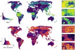
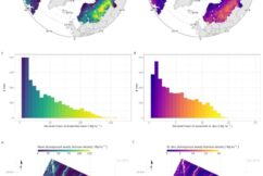
Data Release: Version 2.0 of the L4C Global WSCI Fusion Product
De Conto, Armston, & Dubayah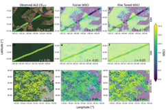
Newest GEDI Article in Machine Learning: Earth Journal
De Conto, Armston, & Dubayah
THE MISSION SCIENCE
GEDI has provided an unprecedented number of highly precise ecosystem structure measurements.>>
THE INSTRUMENT & PLATFORM
GEDI observes nearly all tropical and temperate forests using a self-contained laser altimeter on the International Space Station.>>
Applications of GEDI Data Products
GEDI’s data are of immense value for forest and water resource management and weather prediction.>>