


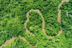
Global Ecosystem Dynamics Investigation (GEDI)
is a high resolution laser ranging of Earth’s forests and topography located in the International Space Station (ISS).
is a high resolution laser ranging of Earth’s forests and topography located in the International Space Station (ISS).
LATEST NEWS
The Times of India highlights new study using GEDI to track tropical forest regrowth
David Roy and Chris Hakkenberg
UMD releases open gedih3 toolkit that simplifies the use of GEDI data to forest mapping
Tiago De Conto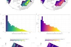
Newest GEDI publication in RSE
Duncanson et al.
THE MISSION SCIENCE
GEDI has provided an unprecedented number of highly precise ecosystem structure measurements.>>
THE INSTRUMENT & PLATFORM
GEDI observes nearly all tropical and temperate forests using a self-contained laser altimeter on the International Space Station.>>
Applications of GEDI Data Products
GEDI’s data are of immense value for forest and water resource management and weather prediction.>>