


- GEDI produces the first high resolution laser ranging observations of the 3D structure of the Earth.
- GEDI makes precise measurements of forest canopy height, canopy vertical structure, and surface elevation.
- GEDI’s enables Earth to Action applications such as forest inventory and analysis, topography mapping, ecosystem services valuation, finance, etc.
- GEDI data is fundamental to increase landscape resilience for hazards (wildfires, floods, hurricanes, landslides, etc.) and to boost economic growth.
- Spaceborne lidar from GEDI has revolutionized forest structure mapping and directly informs NASA’s Earth to Action Strategy.
GEDI INSTRUMENT SAMPLING LIDAR WAVEFORMS FROM ITS POSITION ON THE INTERNATIONAL SPACE STATION. READ MORE:https://svs.gsfc.nasa.gov/13090
The Global Ecosystem Dynamics Investigation (GEDI) produces high resolution laser ranging observations of the 3D structure of the Earth. GEDI’s precise measurements of forest canopy height, canopy vertical structure, and surface elevation greatly advance our ability to understand global dynamics in forest ecosystems and how they change over time.
 GEDI’s unique observations and estimates are of immense value for Earth to Action applications such as forest inventory and analysis, topography mapping, ecosystem services valuation, applications for carbon markets, wildlife habitat conservation and to value impacts and increase resilience for hazards to economic growth and natural resources (wildfires, floods, hurricanes, landslides, etc) .
The GEDI instrument is a geodetic-class, light detection and ranging (lidar) laser system comprised of 3 lasers that produce 8 parallel tracks of observations. Each laser fires 242 times per second and illuminates a 25 m spot (a footprint) on the surface over which 3D structure is measured. Each footprint is separated by 60 m along track, with an across-track distance of about 600 m between each of the 8 tracks. So far, GEDI has produced more then 10 billion of high-quality observations of forest structure.
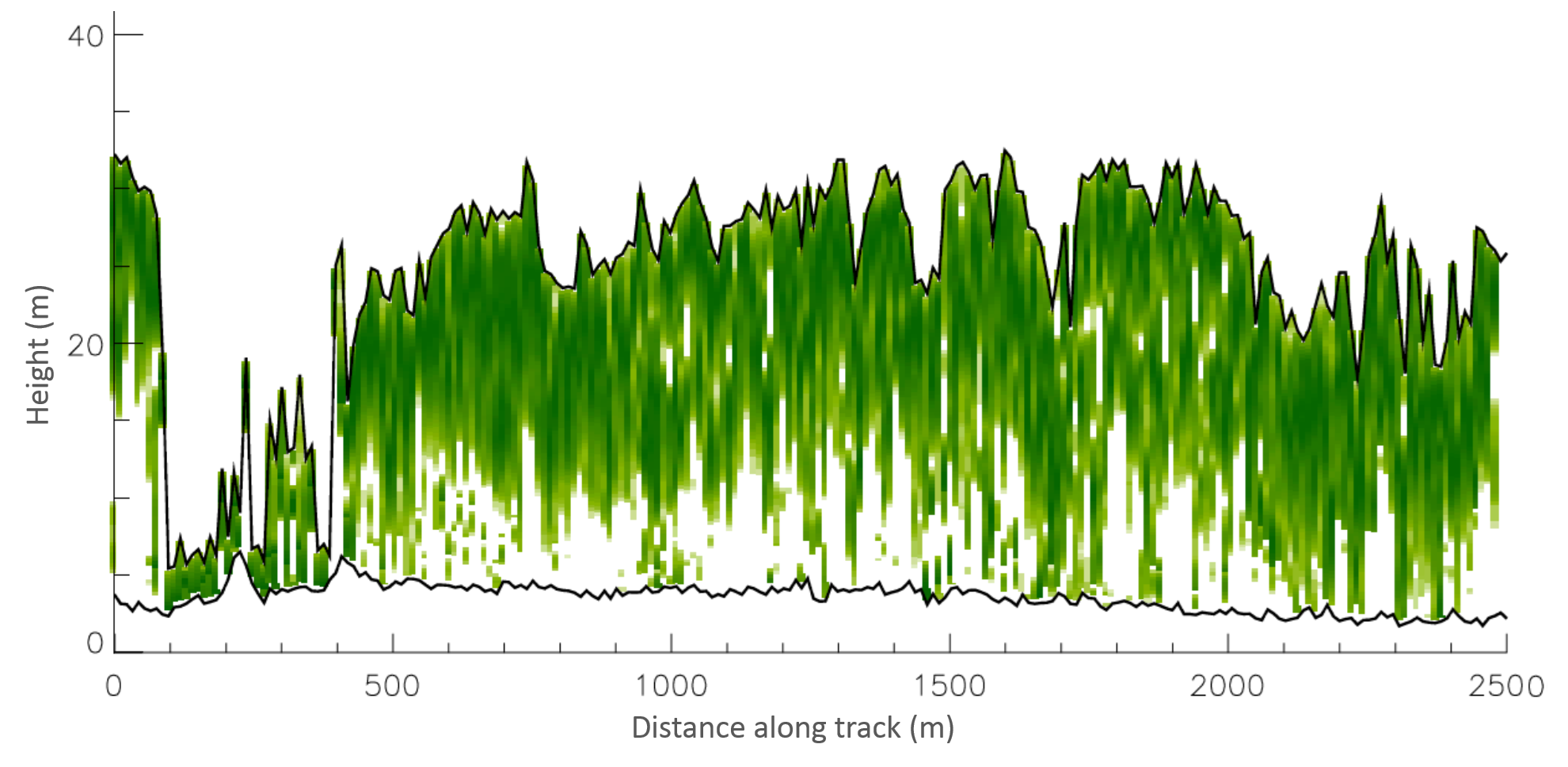
ALONG TRACK LIDAR RETURN ENERGY SHOWING VERTICAL DISTRIBUTION OF VEGETATION
GEDI responds directly to observational priorities set by the National Academy of Sciences and NASA’s Science Mission Directorate, which emphasize the need for lidar vertical structure measurements to address key challenges.
GEDI enforces National Priorities on Driving economic growth, Increasing efficiency and agility, Driving technology innovation and advancement, Strengthening National, Regional, and Local Preparedness and Resilience. And also four 2025 Executive Orders: Immediate Expansion of American Timber Production, Empowering Commonsense Wildfire Prevention And Response, Ensuring American Space Superiority and Restoring Gold Standard Science.
The information derived from GEDI’s lasers further catalyzes observations from ongoing of NASA missions, including the ISRO Synthetic Aperture Radar (NISAR) and the Ice Cloud and Elevation Satellite-2 (ICESat-2), among others. Additionally, GEDI has a formal collaboration with the German Aerospace Center (DLR) to marry its lidar data with the DLR TanDEM-X SAR interferometry mission to produce wall-to-wall maps of canopy heights and other structure metrics. GEDI also collaborates with the European Space Agency in the context of the BIOMASS mission.

GEDI was competitively selected as a NASA Earth Ventures Instrument (EVI) mission in 2014. Cost-capped at $94 M, GEDI is led by the University of Maryland in collaboration with NASA Goddard Space Flight Center. GEDI science data algorithms and products are created by the GEDI Science Definition Team.