


Version 2.0 of GEDI L4C Global Waveform Structural Complexity Index (WSCI) Fusion Product is now available via the Oak Ridge National Laboratory DAAC (ORNL DAAC).
This dataset provides global, wall-to-wall estimates of the Waveform Structural Complexity Index (WSCI) at 25-meter spatial resolution with 3-monthly temporal frequency from 2015 to 2022. The product advances the sparse footprint-level GEDI L4C product by using deep learning to fuse spaceborne lidar observations with multi-sensor Synthetic Aperture Radar (SAR) data, producing spatially continuous estimates of forest structural complexity.
You can access the data and user guide through NASA Earthdata HERE
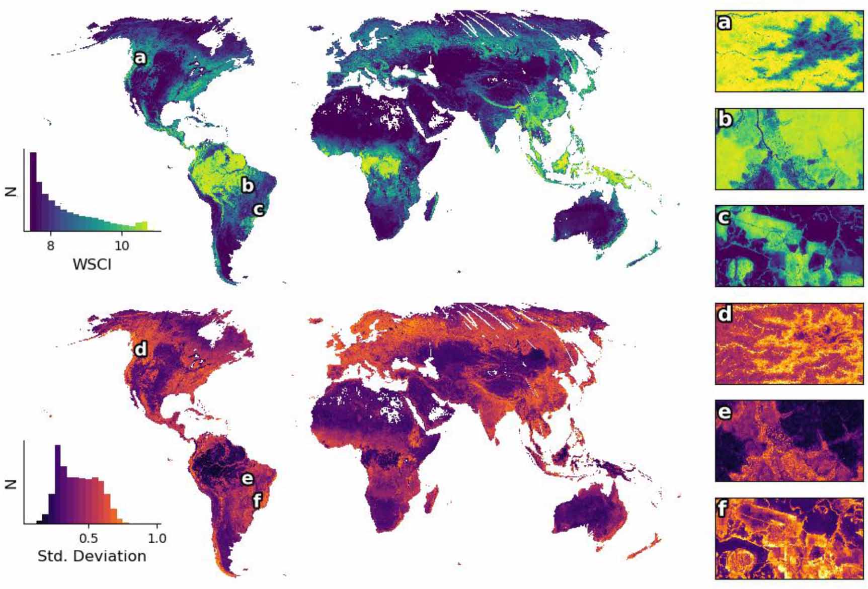
The figure presents the Global map of waveform structural complexity index (WSCI) and associated uncertainty produced by the GEDI-SAR fusion model for April–June 2019–2022. The top panel shows predicted WSCI values while the bottom panel displays the predicted standard deviation. These global inference maps extend beyond GEDI’s orbital coverage and include the Earth’s entire landmass. High-resolution insets highlight: (a), (d) structural complexity along a topographical gradient in Olympic National Park, USA; (b), (e) fire disturbed forest in the Xingu Indigenous Territory in the southern Amazon; and (c), (f) a mosaic of planted and natural forest patches in Brazil’s Atlantic rainforest. Note how transitional areas show elevated predicted uncertainty. White stripes in Northern Russia are sections where either PALSAR or Sentinel-1 data were entirely missing when generating the image mosaic.
Citation
De Conto, T., J. Armston, and R.O. Dubayah. 2026. GEDI L4C Global Waveform Structural Complexity Index (WSCI) Fusion Product, Version 2. ORNL DAAC, Oak Ridge, Tennessee, USA. https://doi.org/10.3334/ORNLDAAC/2474